

</span><br><span class='slider-span'>The Winter (Potala Palace) and Summer (Norbulinka) Palaces of the Dali Lama, Lhasa, Tibet</span>")


, Qatar</span>")


</span><br><span class='slider-span'>From Shiraz to Yazd – Persepolis, Pasargadae and Abarqu</span>")

</span><br><span class='slider-span'>From Shiraz to Yazd – Persepolis, Pasargadae and Abarqu</span>")


</span><br><span class='slider-span'>The Pink City, Jaipur, Rajasthan, India</span>")


, China</span>")


After completing the Lhasa to Everest Base Camp to Nepal journey, through numerous mountain passes and eventually the Himalayan mountain range, I was wondering how high did we in fact go. Depending on which books you read, or which markers you use you are advised of different elevations, I had my GPS on me through the whole journey and found that it was a little off to what people told me, post-researching on Wikipedia even has something else.
So using my GPS as absolute through the whole journey, I compiled a list of significant points in chronological arrival order;
- Kamba-la pass (4746.17)
- Karo-la pass (5022.55)
- Simu-la pass (4366.45)
- Tropu-la pass (4517.37)
- Gyatso-la pass (5193.18) [maximum trip elevation]
- Pang-la pass (5185.01)
- Everest Base Camp (5174.43)
- Lamna-la Pass (5084.07)
- La Lung-la Pass (4990.82)
- Tong-la pass (5113.39)
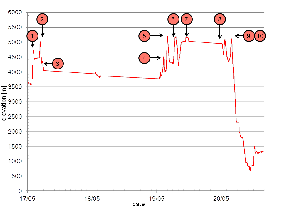
I was slightly disappointed to see that little-known Gyatso-la pass was the highest we had been at 5200 metres and Everest Base Camp at 5175 metres was a little lower. Interesting was also that we descended 4500 metres in roughly ten hours from Everest Base Camp to the China-Nepal border which sits in a natural valley.
(Wikipedia states Everest Base Camp as 5150 metres and Gyatso-la pass as 5520 metres)